


🧗‍♂️Random Restart

Recent Notes

  • Military Grid Reference System (MGRS)

    Aug 05, 2026

    • Coordinate Systems

      Aug 05, 2026

      • Earth-Centered, Earth-Fixed Coordinate System (ECEF)

        Aug 04, 2026

        PortfolioArtificial IntelligenceRoboticsSoftwareEngineeringGitHub
        Home

        ❯

        Robotics

        ❯

        Coordinate Frames & Transforms

        ❯

        Coordinate Systems

        ❯

        Geodetic Coordinate System

        Geodetic Coordinate System

        Aug 03, 20261 min read

        Intro

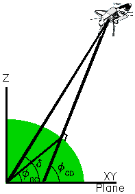
        A geodetic coordinate system defines positions on Earth using latitude, longitude, and ellipsoidal height, where the coordinates are defined relative to a reference ellipsoid, such as the WGS 84 reference ellipsoid.

        Components

        • Reference Ellipsoid
        • Latitude (φ)
        • longitude (λ)
        • height (h)
        description

        https://science-data.larc.nasa.gov/LITE/level1doc/geodetic_coords.html


        Graph View

        • Intro
        • Components

        Backlinks

        • Earth-Centered, Earth-Fixed Coordinate System (ECEF)
        • Universal Transverse Mercator (UTM)

        Created with Quartz v4.5.1 © 2026

        • GitHub
        • Discord